Volcanoes
Eldfell: Iceland’s Surprise Eruption That Changed a Community Forever
In the early hours of January 23, 1973, the small Icelandic island of Heimaey experienced one of the most dramatic and unexpected natural disasters in the country’s history. A new volcano, Eldfell, suddenly erupted without warning, forcing the evacuation of nearly all 5,300 inhabitants of the island. What followed was not just a geological event, but a remarkable story of survival, innovation, and resilience that still captivates volcano enthusiasts and travelers to this day.
Photo credit for the feature photo from the 1973 eruption in Westman Islands: Mats Vibe Lund.
Located in the Westman Islands (Vestmannaeyjar) archipelago off Iceland’s south coast, Eldfell rose quickly from the earth, reshaping the island's landscape and rewriting its future. Today, Eldfell is not just a monument to the power of volcanic activity, but a living reminder of how a community can adapt and thrive in the face of extreme natural forces.
Where Is Eldfell?
Eldfell is situated on Heimaey, the largest and only inhabited island in the Westman Islands chain. The archipelago itself is the product of volcanic activity, with islands and sea stacks created over millennia by eruptions from the seabed. Heimaey, in particular, is geologically active due to its location on the Mid-Atlantic Ridge, where the North American and Eurasian tectonic plates pull apart.
The island's volcanic origins are impossible to ignore. Before 1963, the most notable eruption in the area had created Surtsey—a new island formed from the sea just southwest of Heimaey. But it was Eldfell’s 1973 eruption that truly left a mark, not only on the map but on Icelandic society.
The 1973 Eruption: A Night That Changed Everything
The eruption began without warning in the early hours of January 23. A fissure nearly one kilometer long opened on the eastern edge of Heimaey, just outside the town. Lava fountains shot into the sky, and thick ash began to fall across the island. Residents, most of whom were asleep when the eruption began, were jolted awake by the noise and tremors.
Remarkably, the entire fishing fleet—the community’s economic lifeline—was in the harbor that night due to poor weather. This stroke of luck made evacuation by sea possible. Within hours, nearly all 5,300 residents were transported to the mainland, many with only the clothes on their backs. It was one of the most efficient emergency evacuations in modern history.
As the days and weeks passed, the eruption continued. Lava flowed relentlessly toward the town, engulfing homes and burying entire neighborhoods. Ash blanketed the landscape, and buildings collapsed under its weight. But amid the destruction, a daring plan was launched: to cool the advancing lava with seawater in hopes of saving Heimaey’s harbor—the island’s vital link to the outside world.
Over six months, engineers and volunteers pumped millions of gallons of cold seawater onto the hot lava, slowing its advance. The effort was unprecedented, and against all odds, it worked. The harbor was saved, and with it, the future of the island.
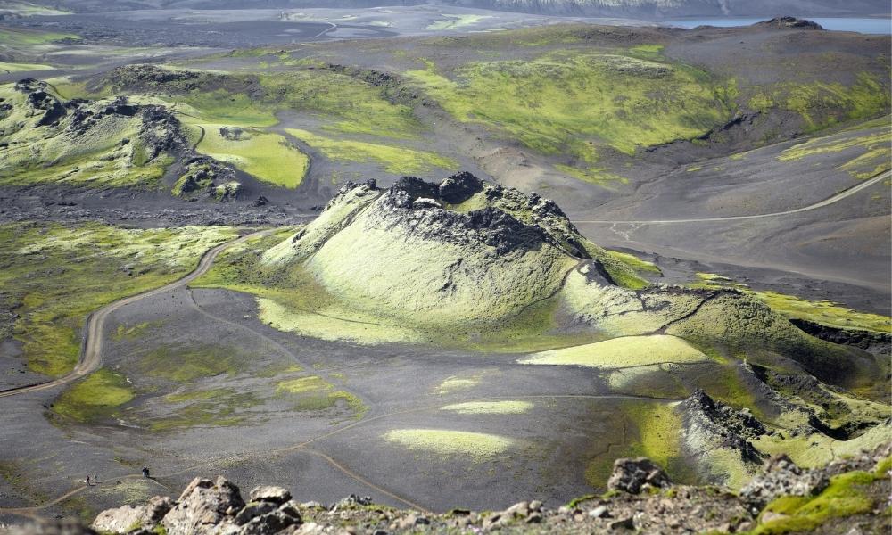
Geological Identity of Eldfell
Eldfell is classified as a cinder cone volcano, a relatively small but steeply sloped type formed by lava fragments that fall close to the eruptive vent. The volcano reaches a height of about 200 meters (656 feet) above sea level and continues to stand as a striking red peak on the island’s landscape.
The eruption itself displayed a mix of Strombolian and Hawaiian activity—characterized by dramatic lava fountains and fluid basaltic lava flows. This combination is relatively common in Iceland, a land shaped by its position on the East Volcanic Zone, where tectonic plates diverge and magma rises frequently to the surface.
The landmass added by the eruption significantly increased Heimaey’s size. What had been farmland or coastline became hardened lava field, and the island's silhouette was forever altered.

Visit the Westman Islands and you can still see buildings half-buried under lava and tephra.
The Lasting Impact on Heimaey and Its People
The aftermath of the eruption was both devastating and inspiring. Hundreds of homes were destroyed or buried under lava and ash, leaving many families displaced. Infrastructure critical to the fishing industry was severely damaged, threatening the island’s economic stability.
And yet, the response became a symbol of Icelandic ingenuity. The lava-cooling operation, once thought impossible, became a case study in volcanic crisis management. Scientists gained invaluable data, and engineers developed new techniques for lava diversion that are still referenced today. In fact, similar methods were later used during eruptions on the Reykjanes Peninsula to protect roads and power plants.
Even after the eruption ended in July 1973, the story of Heimaey continued. From 1974 to 1988, the community used residual heat from the still-warm lava to heat homes and water—an example of sustainable innovation born from disaster.
Eldfell Today: From Disaster Site to Destination
In the decades since the eruption, Heimaey has transformed its hardship into a powerful cultural and educational resource. Today, Eldfell and its surrounding lava fields attract visitors from around the world who come to witness the dramatic evidence of nature’s power.
One of the main attractions is the Eldheimar Museum, a beautifully designed facility built around an excavated house that was buried during the eruption. Visitors can walk through the remains of the home, frozen in time beneath ash and lava, and experience the human side of the natural event. The museum offers detailed exhibits that explore the eruption, the evacuation, and the island’s remarkable recovery.
For travelers and geology buffs, hiking to the top of Eldfell is a must. The trail winds through black and red volcanic rock, still warm in some places, and offers sweeping views of the island and the Atlantic Ocean. It’s a rare chance to stand on a relatively young volcano and see the scars it left behind.
The town of Heimaey has rebuilt itself with resilience and pride. New homes, schools, and fishing infrastructure stand where ash once lay. And while the memory of 1973 is still fresh in local consciousness, there is also a sense of triumph—of a community that endured, adapted, and rebuilt stronger than before.
Monitoring and Future Risks
Even though Eldfell has remained quiet since 1973, scientists continue to monitor seismic and volcanic activity in the area closely. The Westman Islands remain geologically active, and any signs of magma movement or ground deformation are closely watched by Iceland’s meteorological and geological institutes.
Technology such as GPS sensors, thermal imaging, and seismometers provides real-time data that helps predict potential eruptions. These systems are part of Iceland’s broader commitment to volcanic preparedness, ensuring that any future events are detected early and met with swift response.
Eldfell in the Context of Global Volcanism
Eldfell’s story shares common threads with some of the world’s most famous volcanic eruptions. Like Mount St. Helens in the United States (1980), Eldfell reshaped its surrounding landscape in a matter of days. Like Parícutin in Mexico (1943), it emerged suddenly, creating a new volcanic cone where none existed before. And like Iceland’s own Eyjafjallajökull (2010), Eldfell disrupted daily life and offered valuable lessons to the global scientific community.
What makes Eldfell unique, however, is the human connection. It’s not just a volcano—it’s a chapter in the story of a town and its people. It represents the intersection of geology and humanity, where science meets survival.

The view from top of the Eldfell volcano over the town of Vestmannaeyjar.
Planning a Visit to Eldfell
For those intrigued by active geology, Eldfell offers a powerful, immersive experience. The island is reachable by ferry or plane from mainland Iceland, and summer is the best time to visit due to weather and accessibility. Once on Heimaey, the hike to Eldfell’s summit takes about an hour and rewards visitors with unforgettable views of a landscape born from fire.
Whether you’re a seasoned volcanophile or a curious traveler, Eldfell stands as one of the most dramatic and educational volcanic sites in the world. It offers not only insight into geological processes but also a powerful story of community resilience and adaptation. And as you walk the hardened paths of lava, with the Atlantic stretching out on every side, it’s hard not to feel the sheer force of nature that once rose from the ground beneath your feet.