Volcanoes
Katla 1918 The eruption that made Iceland bigger
A giant awakens. Katla’s 1918 eruption sent an ash plume high above the glacier and unleashed a flood that transformed the South Coast.
A giant awakens. Katla’s 1918 eruption sent an ash plume high above the glacier and unleashed a flood that transformed the South Coast.
Fire melted ice. A monstrous flood followed. And Iceland got bigger.
On October 12, 2026, we mark 108 years since Katla’s last confirmed major eruption began beneath Mýrdalsjökull glacier. This anniversary recalls an extraordinary chain of events: an eruption beneath the ice, a flood carrying giant icebergs, and volcanic sediment that pushed parts of Iceland’s coastline farther into the sea.
Katla’s 1918 eruption is a powerful example of how Iceland’s volcanoes can reshape a landscape through water as well as molten rock. It is also a human story, remembered by communities whose farms, animals and daily lives lay in the path of the disaster.
For us at Lava Show, that history reaches into our own family. Our co-founder Júlíus’s great-grandparents connect us personally to the eruption. Their dramatic story is told at Lava Show in Vík, where the history of Katla and the experience of real molten lava bring Iceland’s volcanic landscapes into sharper focus.
To understand what happened in 1918, start with the setting. A volcano. A glacier. And a huge amount of heat.
When fire meets a glacier

Fire beneath the ice. A glacier can conceal an active volcano, and an eruption can rapidly turn part of that ice into floodwater.
Fire beneath the ice. A glacier can conceal an active volcano, and an eruption can rapidly turn part of that ice into floodwater.
Katla lies beneath Mýrdalsjökull in South Iceland. Much of the volcano is hidden from view, including its large summit caldera: a broad volcanic depression filled with ice. In places, the ice above the caldera is hundreds of metres thick. [2]
When an eruption begins in this setting, magma transfers heat to the surrounding ice and meltwater. Ice melts, water moves and contact between magma and water can intensify explosive fragmentation. The glacier becomes an active part of the eruption.
The 1918 eruption began on October 12 and was over by November 4, approximately 23 days later. On its first day, the eruption column reached an estimated 14–15 kilometres into the atmosphere. Ashfall was accompanied by lightning and thunder. [1]
Volcanic ash deserves a quick explanation. It consists of tiny fragments of rock, minerals and volcanic glass, rather than the soft residue left by a wood fire. These particles can travel with the wind and settle far from the vent. [3]
Above the glacier, the sky told one part of the story. The meltwater escaping from the ice told another.
A flood of unimaginable force

Jökulhlaup means glacial outburst flood. This historical reconstruction maps the October 12, 1918 flood routes across Mýrdalssandur. Map credit: Guðrún Larsen, preliminary map 2005; published in Larsen 2010.
Jökulhlaup means glacial outburst flood. This historical reconstruction maps the October 12, 1918 flood routes across Mýrdalssandur. Map credit: Guðrún Larsen, preliminary map 2005; published in Larsen 2010.
The Icelandic word jökulhlaup describes a glacial outburst flood: water escaping rapidly from a glacier or a glacier-dammed reservoir. At Katla, heat from an eruption can generate huge volumes of meltwater, which then rush downhill carrying ice and sediment.
In 1918, floodwater swept across Mýrdalssandur, the broad outwash plain southeast of the glacier. Published estimates place peak discharge at roughly 100,000–300,000 cubic metres per second. At the upper estimate, that is 300 million litres passing a point in a single second. These are reconstructed estimates, rather than a precise modern measurement. [4]
Research distinguishes two main phases on October 12. The first spread widely across the plain through several river routes. The second emerged from beneath the glacier’s snout and was concentrated farther west, carrying a particularly heavy load of icebergs and sediment. [1]
The map helps make sense of that movement. Water followed the terrain, divided into different routes and spread across low-lying ground. Reading it turns an abstract word, flood, into something much more tangible: a disaster moving through a lived-in landscape.
Imagine this flood and then add icebergs

Icebergs left behind after Katla’s 1918 flood. Look for the two people standing near the top of the ice formation on the right. Their size reveals the extraordinary scale of what the water transported.
Icebergs left behind after Katla’s 1918 flood. Look for the two people standing near the top of the ice formation on the right. Their size reveals the extraordinary scale of what the water transported.
At first glance, this historical photograph could be mistaken for a rocky cliff. Look more closely. These are enormous masses of ice deposited after the flood. Now find the two people standing near the top of the formation on the right.
They provide the photograph’s most useful scale. The ice towers above the ground, while the people appear tiny. Imagine that mass moving with floodwater, surrounded by other icebergs, volcanic debris and sediment. The danger becomes easier to grasp.
A flood of this kind combines moving water with a heavy, destructive load. The landscape records both the water’s passage and the material it leaves behind. Ice eventually melts, but deposited sediment can remain long after the flood has gone.
The photograph also helps bridge geology and human experience. A discharge estimate tells us how much water moved. Two people beside an iceberg help us imagine what that movement meant at ground level.
The ice eventually disappeared. The photograph remains, preserving a sense of scale that the flood deposits alone can no longer show.
How Katla made Iceland bigger

Iceland actually got bigger. Sediment carried into the sea by Katla’s 1918 floods extended parts of the southern coastline by several kilometres. Waves and currents subsequently reshaped the new deposits.
Iceland actually got bigger. Sediment carried into the sea by Katla’s 1918 floods extended parts of the southern coastline by several kilometres. Waves and currents subsequently reshaped the new deposits.
A volcano can build land without producing a neat new lava field. In 1918, floodwater carried vast quantities of volcanic material towards the coast. As the flow entered the sea and lost energy, sediment accumulated, extending the shoreline.
One historical synthesis reports an initial coastline advance of more than four kilometres, reduced to about two kilometres by the middle of winter. The figures describe a changing shoreline, rather than a permanent addition of identical width along the entire South Coast. [4]
The sea kept working on the deposits. Waves and currents eroded, moved and redistributed sediment. Around Víkurfjara, the beach continued growing during the decades after 1918 before later retreating. [5]
This is an important part of the story. “Iceland got bigger” captures a real transformation, but coastlines remain mobile. An eruption and its floods can deliver new material; the ocean then begins rearranging it.
When you look along a black sand beach, you are seeing the result of many processes working over time. Volcanic fragmentation, transport by rivers and floods, and the action of the sea all contribute to the landscape. Katla’s 1918 eruption made that relationship spectacularly visible.
108 years quiet and still very much alive

A glacier landscape in South Iceland. Katla remains active beneath Mýrdalsjökull, even though 108 years have passed since its last confirmed major eruption.
A glacier landscape in South Iceland. Katla remains active beneath Mýrdalsjökull, even though 108 years have passed since its last confirmed major eruption.
Historically, Katla’s volcanic system erupted at least 21 times over approximately 1,100 years, with an average interval of around 50 years. That is roughly twice a century. By October 12, 2026, the interval since the 1918 eruption has reached 108 years. [2]
It is a striking comparison, but an average is not an appointment. Eruptions are governed by changing conditions underground, and the historical record cannot supply a reliable date for Katla’s next major eruption.
There may have been smaller eruptions beneath the ice in 1955, 1999 and 2011, although these events remain uncertain. That is why “last confirmed major eruption” is more careful wording than an absolute claim that nothing has happened since 1918. [6]
Scientists monitor Katla through earthquake activity, ground movement, water measurements and other observations. These help identify changing conditions and possible unrest; they do not turn the anniversary into a countdown. [2]
Katla’s long pause gives this anniversary an extra sense of suspense. We can recognise that suspense while keeping the science clear. For current conditions, visitors should consult the Icelandic Meteorological Office and follow local guidance, rather than treating a historical article as a live hazard update.
For us this story is personal
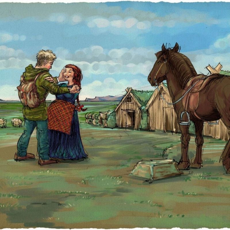
An illustration from the storytelling at Lava Show in Vík. Katla’s 1918 eruption is part of co-founder Júlíus’s family history through his great-grandparents.
An illustration from the storytelling at Lava Show in Vík. Katla’s 1918 eruption is part of co-founder Júlíus’s family history through his great-grandparents.
At Lava Show, the Katla story has a connection that reaches beyond the historical record. Our co-founder Júlíus’s great-grandparents link his family directly to the events of 1918, and their dramatic story is shared as part of the experience in Vík.
That connection gives the geology a human dimension. A glacier can be described in metres, a flood in cubic metres per second and a coastline in kilometres. Family history brings us back to the people living among those forces.
The illustration shown here comes from the storytelling in the Vík show. It places people, animals and farm buildings in the landscape, inviting us to think about what was at stake when that familiar world was disrupted.
At Lava Show in Vík, that personal history connects the volcanic event with the lives it touched. It is a story carried forward through a family, and shared with visitors exploring the landscape where it happened.
Understanding Iceland involves both. The volcanoes explain how the land changes. The people who live beside them help explain what those changes mean.
The story continues at Lava Show in Vík

Get close to real molten lava at Lava Show in Vík, where Katla’s history meets live demonstrations and personal storytelling. Book the award-winning experience at lavashow.com/vik.
Get close to real molten lava at Lava Show in Vík, where Katla’s history meets live demonstrations and personal storytelling. Book the award-winning experience at lavashow.com/vik.
At Lava Show in Vík, we bring visitors close to real molten lava, heated to approximately 1,100°C and poured into a purpose-built showroom. Watching it move and cool gives a physical sense of volcanic heat that photographs alone cannot provide. [7]
The volcanic material used in the shows comes from Katla’s 1918 eruption. Remelting it creates a direct connection between the historical event and the glowing material visitors see today. [8]
We are passionate about helping people understand Iceland’s incredible landscapes through that experience. Our approach combines geological explanation with entertainment and the stories of people who live with volcanoes in their backyard. For us, that is edutainment in its truest form.
Visit early in your South Coast journey and take that understanding with you. The glaciers, rivers and black sand beaches you encounter afterwards become parts of a connected story, shaped by heat, ice, water and time.
On this 108th anniversary, share Katla’s story with someone who loves volcanoes, explore more articles and the Lava Academy Podcast on our website, and join us in Vík to hear the personal history behind the eruption.
Book the award-winning experience in Vík
Sources and further reading
[1] Larsen, Janebo and Gudmundsson 2021
The explosive basaltic Katla eruption in 1918 Part I
[2] Icelandic Meteorological Office
[3] US Geological Survey
[4] University of Iceland
Annal of magmatic events in Iceland 1900 to 2010
[5] Katla UNESCO Global Geopark
[6] Katla UNESCO Global Geopark
[7] Lava Show
Images by Lava Show,, archival images from the 1918 Katla eruption, Shutterstock
The historical flood map retains its original attribution.
Written by Ragnhildur Ágústsdóttir, co-founder of Lava Show. Listen to her on the Lava Academy Podcast and follow her on Instagram.